Joseph Henry
"Joe Boy" Flinn
1931-1936
A family history of Joseph Henry Flinn's short life, the November 12, 1936 hunting accident near Solsberry, Indiana, his burial at Saint Mary Cemetery in Saint Bernard, Ohio, and the Flinn and Freudenberg families connected to him.
Cincinnati / Indianapolis / Solsberry / Saint Bernard
Contents
Joe Boy
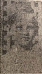
Joseph Henry Flinn, known to his family as "Joe Boy," was born in 1931 in Cincinnati, Ohio. He was the eldest child of Joseph G. Flinn and Margaret (Freudenberg) Flinn. By the mid-1930s the family had moved to Indianapolis and was living at 1944 Ruckle Street.
At the time of Joseph Henry's death, the household included three younger children: Margaret Mary, Jimmy, and Shirley Jean.
Joseph's name also appears in records as Joseph Flinn Jr., reflecting that he shared his father's given name. The same article preserved the younger children's approximate ages: Margaret Mary was about four, Jimmy was about two, and Shirley Jean turned one year old on November 13, one day after Joe Boy died.
Name: Joseph Henry Flinn
Family nickname: "Joe Boy"
Born: 1931, Cincinnati, Ohio
Parents: Joseph G. Flinn and Margaret Freudenberg Flinn
Residence in 1936: 1944 Ruckle Street, Indianapolis, Indiana
The hunting trip
The family's home at 1944 Ruckle Street in Indianapolis was roughly 75 to 85 miles from Solsberry by modern roads. The newspaper places Joe Boy with his parents and George Hendrixson, as the paper spelled the name, in woods on the W. H. Brown farm. This was a deliberate trip into Greene County, a place connected to the family's older ties there.
Greene County land records and plat books show older Flinn/Flynn land about six miles from the likely Brown farm area. The accident site named in the newspaper was the W. H. Brown farm, not Flinn or Flynn land.
The newspaper also says Joseph had hunted with his father before. He was still very young, but this was not the first time he had gone along.
The accident, November 12, 1936
On Thursday, November 12, 1936, the hunting party stopped for water in woods on the W. H. Brown farm near Solsberry, about fifteen miles west of Bloomington. While they were stopped, George Hendrixson's loaded shotgun was propped against a stone. Joe Boy tripped against it, and it fired.
The newspaper account
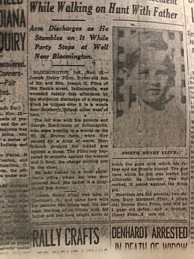
The article appeared under the headline "While Walking on Hunt With Father" and the subhead "Arm Discharges as He Stumbles on It While Party Stops at Well Near Bloomington." It read:
BLOOMINGTON, Ind., Nov. 12: Joseph Henry Flinn, 5-year-old son of Mr. and Mrs. Joseph G. Flinn of 1944 Ruckle street, Indianapolis, was wounded fatally this afternoon by the accidental discharge of a shotgun when he tripped over it in a woods near Solsberry, fifteen miles west of here.
The lad was with his parents and George Hendrixson of Indianapolis, who were hunting in a woods on the W. H. Brown farm, when they paused for a drink of water. Hendrixson propped his loaded gun against a stone. The Flinn boy happened to stumble against the weapon and it fired, the charge striking him in the chest.
He was rushed to a local physician's office where he was pronounced dead. His father is a Greyhound bus driver.
Joseph Henry Flinn was born in Cincinnati, O., and came here with his parents two years ago. He had been hunting often before with his father and had been taught never to touch the guns with which his father and his friends hunted. The gun upon which he fell was loaded but although its hammer was not cocked, it rested against the firing pin.
Survivors are the parents, two sisters, Mary Margaret Flinn, 4 years old; Shirley Dean Flinn, who will be 1 year old today, and a brother, Jimmy Flinn, 2 years old.
The article contained several small errors. "Shirley Dean Flinn" was Shirley Jean Flinn, later Shirley (Flinn) Meineke. "Mary Margaret" was Margaret Mary Flinn. The statement that Shirley would be one year old "today" was also off by one day; Shirley was born on November 13. George's surname is not settled here: the newspaper printed Hendrixson, while family memory uses Hendrickson.
Family memories from Shirley
Joe Boy's sister, Shirley (Flinn) Meineke, kept several family memories that do not appear in the public report. She recalled being told that Margaret Flinn asked George Hendrickson, before the accident, whether the gun's safety was on. Hendrickson reportedly answered, perhaps teasing, "That's the trouble with you women, always worrying."
Shirley also remembered that Joe Boy's last word was "Mother." This detail is not part of the newspaper account, but it is part of the family account preserved by Shirley.
Years later, after Shirley was old enough to drive, her mother, Margaret, asked her to take her to the bus station. Margaret then traveled by bus to visit George Hendrickson and speak with him. When she arrived, she found him to be a very broken man. Shirley recounted that Margaret forgave him.
Firearm notes
One of Shirley's sons, a hunter familiar with firearms, pointed out one important mechanical detail in the newspaper account: the gun was loaded, the hammer was not cocked, and the hammer rested against the firing pin.
This suggests an older exposed-hammer cartridge shotgun, but not necessarily one without any safety feature. Many such guns used a half-cock notch to hold the hammer back from the firing pin; later designs used rebounding hammers. If the newspaper's description was accurate, the hammer was likely fully lowered rather than held at half-cock, or the gun had an older or worn mechanism that allowed the hammer to rest against the firing pin.
In that condition, a blow or jar could drive the firing pin into the primer even though the hammer was not fully cocked. George may have believed the gun was safe because the hammer was down. He may not have understood the danger of a loaded gun with the hammer resting against the firing pin. That would also explain why he answered Margaret's question as if she were worrying for no reason.
Newspaper clippings
Two newspaper clippings are included here. The accident notice is the source for the article quoted above. The funeral notice records that services were arranged in Cincinnati, linking the Indiana accident to the family's Ohio burial place.
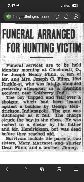
The accident notice also preserves the Indianapolis address, the father's occupation, and the approximate ages of the younger children, even where some details needed correction.
Together, the clippings connect Indianapolis, Solsberry, Cincinnati, and Saint Bernard.
Burial
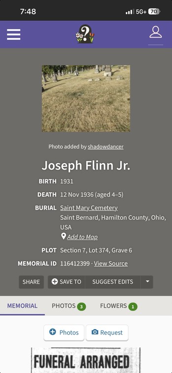
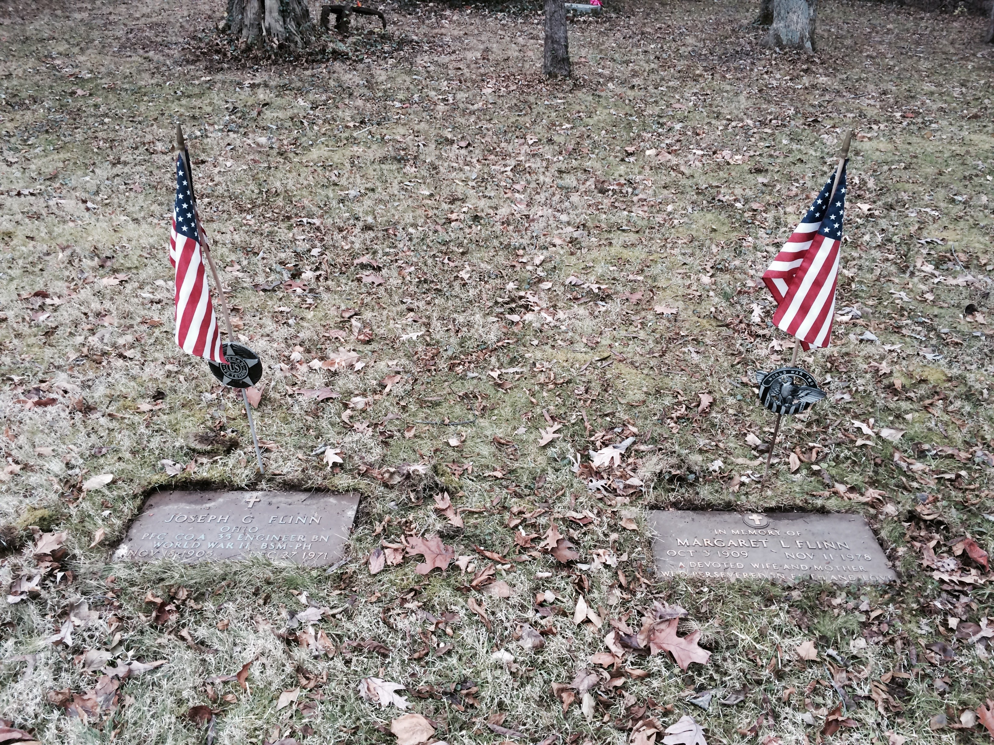
Joseph Henry Flinn is buried at Saint Mary Cemetery and Mausoleum, 701 E. Ross Avenue, Saint Bernard, Hamilton County, Ohio. His grave is located at Section 7, Lot 374, Grave 6. He rests with his maternal grandparents, Henry John and Augusta Freudenberg.
The Cincinnati funeral notice fits this burial location. After the accident in Indiana, Joseph Henry was returned to the Cincinnati and Saint Bernard community of his mother's family.
The cemetery is a German Catholic parish cemetery in Saint Bernard and is managed through the Cincinnati Catholic Cemetery Society. The cemetery entrance is near 39.1695 N, 84.4907 W.
Open Saint Mary Cemetery in Google Maps.
Find a Grave Memorial ID 116412399 and Mark R. Gideon's family tree entry both support that lot placement with the Freudenberg family.
Parents and siblings
Father
Joseph G. Flinn was identified in the newspaper account as a Greyhound bus driver. The family was living in Indianapolis at the time of the accident, having come there from Cincinnati about two years earlier.
Mother
Margaret (Freudenberg) Flinn was born October 3, 1909. She was a daughter of Henry John Freudenberg and Augusta Wiechaus Freudenberg of Cincinnati.
Margaret died November 11, 1978. Through her, Joseph Henry was tied closely to the Freudenberg family and to Saint Mary Cemetery, where he was buried with his maternal grandparents.
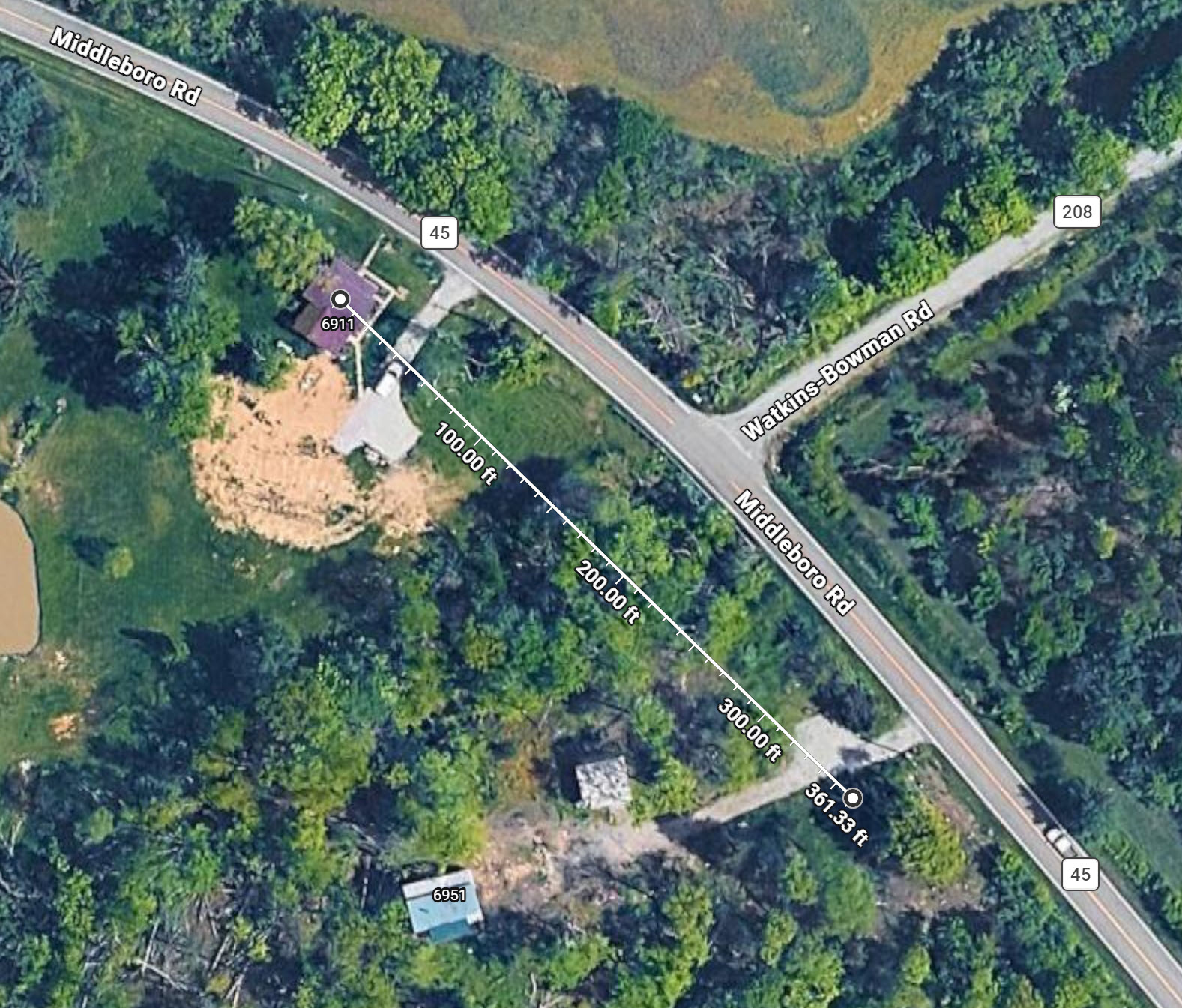
Open Joseph and Margaret Flinn's former home at 6911 Middleboro Road, Blanchester, Ohio in Google Maps. Joseph G. and Margaret both died at this home. Their graves are about 120 yards southeast in the nearby Osborn Cemetery in Harlan Township: open the gravesite in Google Maps.
Siblings
The younger Flinn children in 1936 were Margaret Mary, Jimmy, and Shirley Jean. Their names matter because the newspaper account used them while reporting Joseph Henry's death.
The Freudenberg family
Joseph Henry's maternal family, the Freudenbergs, were German Catholics rooted in Cincinnati and Saint Bernard. That side of the family explains why the funeral and burial records point back to Ohio after the accident in Indiana.
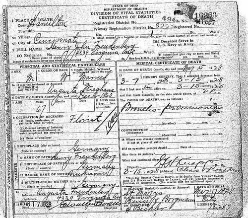
Henry John Freudenberg lived at 4339 Virginia Avenue, also described in records as Badgley Street or Virginia Avenue Hill. His death certificate ties the family directly to Saint Mary's Cemetery, which was already part of the family's history before Joseph Henry's death.
Henry John Freudenberg was born December 6, 1860, in Germany and worked as a florist in Cincinnati. He died March 15, 1928, of broncho-pneumonia and was buried at Saint Mary's Cemetery two days later. His wife, Augusta Wiechaus Freudenberg, was the informant on his death certificate and was listed at the Virginia Avenue address.
Henry John's death certificate names his father as Henry Freudenberg of Germany; his mother's maiden name was not recorded. Augusta Wiechaus Freudenberg was also from Germany. The undertaker listed on Henry John's death certificate was Busse & Borgmann.
The thirteen children
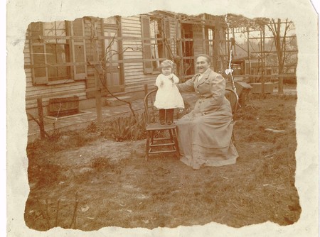
Henry John and Augusta Freudenberg had thirteen children. A family photograph taken around 1915 at the home on Badgley Street, also remembered as Virginia Avenue Hill, identifies George, Henry, Marie, Gus, Neddie, Dick, Louise, Otto, Hannah, Bernard, Margaret, Frank, and their parents. The small girl standing near Henry John is Margaret Freudenberg, Joseph Henry's mother.
Several of Margaret's siblings remained close to the family story. Jean, Louise, and Otto Freudenberg never married. Louise and Otto are confirmed buried at Saint Mary's Cemetery, and family memory remembered Otto as very close to Margaret's family.
Where the accident happened
The maps and overlays narrow the accident site to the countryside around Solsberry in eastern Greene County. The evidence points to a likely Brown farm cluster, not a fully proven parcel.
The location work used the newspaper description together with Greene County plat books from 1879, 1906, and 1937, plus the 1956 USGS Solsberry topographic quadrangle. The relevant township-and-range area is Beech Creek Township, T.8N, R.3W and R.4W.
The maps also show older Flinn and Flynn land in neighboring Center Township, roughly six miles south. That relationship gives the hunting trip local family context, but the accident itself remains tied to the Brown farm named in the article.
The Brown farm
The newspaper places the accident "in a woods on the W. H. Brown farm." The 1937 Hixson Plat Book shows Brown family land near Solsberry at the section 28/33 boundary of Beech Creek Township, along the route now associated with State Road 43. The parcels are labeled with initials that are not perfectly clear, including entries read as "F+M Brown" or possibly "F+W Brown," and a nearby V. Brown parcel in section 29. A second close read of the plats did not show a clean "W. M. Brown" label.
No plat image examined so far gives a clean parcel label reading "W. H. Brown." The section 29 parcel reads as "V. Brown 50," not W. M. Brown, and the W. M. label near the earlier working estimate is W. M. Thompson in section 32. Even so, the Brown parcels by sections 28 and 33 are the only Brown land found in the immediate area on the relevant plat maps, and they match the article's description of a farm near Solsberry and west of Bloomington.
The nearby V. Brown parcel is shown as about 50 acres in section 29. The section 28/33 Brown parcels total about 120 acres, which fits the size of a working farm in the period.
This location should be treated as likely but not fully verified until a Greene County deed, death certificate, or coroner record directly ties W. H. Brown to the exact parcel.
The working coordinate used for the likely former Brown farm area is approximately 39.09744, -86.73592. That location is about 1.45 miles from Solsberry and about 11.8 miles straight-line from the Monroe County Courthouse in Bloomington. By road, it fits the article's "fifteen miles west" description.
Open the likely former Brown farm area in Google Maps.
The overlay used in this report shows sections 27, 28, 33, and 34, with State Road 43 running through the Brown parcel area. That view makes the newspaper's "near Solsberry" and "west of Bloomington" descriptions fit together.
Flinn, Flynn, and Brown land
The land records put the hunting trip in a wider local setting. Family-connected names had been present in Greene County for decades. The Brown farm appears in the Solsberry map record sometime between the early twentieth century and the 1937 plat.
1879
In the 1879 Greene County atlas, no Brown parcels appear in Beech Creek Township near Solsberry. Section 28 near Solsberry was held by names such as Wm. Gray and H. Shields. In neighboring Center Township, however, three Flinn landholders appear: A. Flinn with 120 acres in section 33, Wm. Flinn with 120 acres in section 30, and Eliz. Flinn with 40 acres in section 30. Together, those holdings show a substantial Flinn presence in the area by the late nineteenth century.
The 1879 section 28 neighbors show who owned the land before the Brown farm appears on later maps: Wm. Gray and H. Shields are each shown with about 195 acres near Solsberry.
Wm. Flinn's section 30 land was near an M.E. Church shown on the 1879 plat. Details like that help place the family in a neighborhood instead of leaving them as acreage totals.
1906
The 1906 Greene County map still does not show Brown land near Solsberry. Section 28 remained in the hands of Gray, Shields heirs, Watson, and nearby landowners. A Floyd Brown parcel appears farther north in Beech Creek Township, outside the section 28/33 area associated with the later farm research.
In 1906, the section 28 names included Wm. Gray with about 120 acres, Henry Shields heirs with about 156 acres, and Ira E. Watson. That is the ownership pattern that appears to have changed before the 1937 Brown parcels were mapped.
The Floyd Brown holding was about 104 acres in sections 2 and 3, roughly five to six miles north of Solsberry. That northern cluster is separate from the Brown land later associated with the accident area.
1937
By 1937, Brown parcels appear near the south side of section 28 and the north side of section 33, directly near Solsberry. A J. H. Flynn parcel also remains in Center Township section 33, roughly six miles south of the Brown farm area. That continuing Flynn presence helps explain the Solsberry-area hunting trip as part of an older Greene County family setting.
The J. H. Flynn 40-acre tract appears to be the last visible plat-map remnant of the older Flinn/Flynn holdings in that part of Greene County.
The 1937 plats also show a northern Brown cluster with names or initials including C. Brown, H. Brown, H. H. Brown, S. Brown, and J. M. Brown in sections 2 and 3. Because that cluster is separate from the section 28/33 parcels, the deed trail between 1906 and 1937 is the most likely way to identify W. H. Brown fully.
Flynn Road still runs through the same Center Township section 33 area where the plat maps show Flinn/Flynn land. The road name is not proof by itself, but it is a useful place-name clue: local road names often preserve the memory of families who owned or occupied land nearby long after the acreage changed hands. The spelling shift from Flinn to Flynn may reflect ordinary record-keeper variation, phonetic spelling, or a later family preference; older county records often moved between those spellings even when referring to the same family line.
Timeline
This chronology puts the family, land, accident, burial, and present-day location details in one sequence.
- Henry John Freudenberg was born December 6 in Germany.
- The Greene County atlas shows three Flinn parcels in Center Township: A. Flinn with 120 acres in section 33, Wm. Flinn with 120 acres in section 30, and Eliz. Flinn with 40 acres in section 30, for a combined 280 acres. No Browns appear anywhere in Beech Creek Township.
- The Greene County map shows Floyd Brown with 104 acres in sections 2 and 3 of Beech Creek Township, about five miles north of Solsberry. Browns still do not appear near Solsberry; sections 28 and 33 were held by the Gray, Shields, and Watson families.
- Margaret Freudenberg was born October 3 in Cincinnati to Henry John and Augusta Wiechaus Freudenberg. The family home was at 4339 Virginia Avenue, also remembered as Badgley Street.
- The Freudenberg family photograph was taken at the home on Badgley Street, showing Henry John, Augusta, and their thirteen children, including young Margaret.
- The Cincinnati directory lists "Freudenberg Henry O 4339 Virginia Av" under florists.
- Henry John Freudenberg died March 15, age 67, of broncho-pneumonia. He was buried at Saint Mary's Cemetery in Saint Bernard, Ohio, on March 17. Property later transferred from his estate to Louise Freudenberg and Otto J. Freudenberg for $1.
- The census shows Augusta Freudenberg listed as a florist, with the home valued at $18,000.
- Joseph Henry "Joe Boy" Flinn was born in Cincinnati to Joseph G. Flinn, a Greyhound bus driver, and Margaret (Freudenberg) Flinn.
- The Flinn family moved from Cincinnati to 1944 Ruckle Street in Indianapolis.
- Shirley Jean Flinn was born November 13.
- Joseph Henry Flinn, age five, was killed in a hunting accident on the W. H. Brown farm near Solsberry, Beech Creek Township, Greene County, Indiana. The family traveled from Indianapolis to hunt near the older Flinn/Flynn land in Center Township. The modern road distance from Indianapolis to the area is approximately 75 to 85 miles. George Hendrixson of Indianapolis owned the shotgun. Joseph tripped against the loaded gun, which discharged into his chest, and he died before reaching medical aid.
- Funeral services were held the following Monday morning in Cincinnati. Joseph Henry Flinn was buried at Saint Mary Cemetery in Saint Bernard, Ohio, Section 7, Lot 374, Grave 6, with his maternal grandparents Henry John and Augusta Freudenberg.
- The Hixson Plat Book shows Brown parcels near the section 28/33 boundary by Solsberry, including joint-initial Brown parcels read as F+M and possibly F+W, totaling about 120 acres, and V. Brown with 50 acres in section 29. The Browns arrived on this land sometime between 1906 and 1937, likely through purchases from the Gray, Shields, or Watson families. J. H. Flynn retained 40 acres in Center Township section 33, the last visible remnant of the 1879 Flinn holdings on the examined plat maps.
- Amelia Freudenberg, wife of Gustave Joachim Freudenberg, died in Cincinnati.
- Margaret (Freudenberg) Flinn died November 11.
- Joseph Henry Flinn's grave is at Saint Mary Cemetery, Section 7, Lot 374, Grave 6. The likely former Brown farm area is near 39.097 N, 86.736 W along State Road 43. Flynn Road in Center Township section 33 still marks the old Flinn/Flynn family land area.
Records searched and next leads
The strongest parts of the research are supported by several independent records: the accident newspaper notice, the Cincinnati funeral notice, the Saint Mary Cemetery burial listing, the Find a Grave memorial, the Freudenberg death certificate, and the Greene County plat maps.
Confirmed findings
- Find a Grave Memorial ID 116412399 places Joseph Flinn Jr. at Saint Mary Cemetery in Saint Bernard, Ohio.
- Mark R. Gideon's Ancestry tree entry, tree #76041462, also places Joseph with the Freudenberg family burial lot.
- The 1937 Hixson Plat Book shows Brown land near Solsberry around the section 28/33 boundary.
- The same 1937 plat set shows J. H. Flynn with 40 acres in Center Township section 33.
- The 1879 Greene County atlas shows A. Flinn, Wm. Flinn, and Eliz. Flinn with a combined 280 acres in Center Township.
- The 1906 Greene County map shows Floyd Brown land farther north, but not Brown land at the later Solsberry accident area.
Negative searches
- The Monroe County death index for 1882-2025 did not show Joseph under Flinn or Flynn, which fits the accident being registered in Greene County.
- The 1879 and 1906 plats did not show Brown ownership in the immediate sections around the later W. H. Brown farm location.
- No plat book examined so far gives a clear "W. H. Brown" label, so the full legal identity of that landowner remains a research target.
Next leads
- Request Joseph Henry Flinn's Greene County death certificate from Greene County Public Health in Bloomfield, Indiana; the notes list a $10 money-order fee and recommend calling first about nephew eligibility.
- Search Greene County deeds for transfers from Gray, Shields, Watson, or nearby owners to a Brown owner between 1906 and 1937.
- Follow up with the Cincinnati Catholic Cemetery Society, cccsohio.org, for the Saint Mary Cemetery lot card or burial register entry.
- Ask the Bloomfield-Eastern Greene County Public Library genealogy desk about land indexes for section 28, Beech Creek Township.
Useful contacts
- Saint Mary Cemetery Office, 701 E. Ross Avenue, Saint Bernard, Ohio; office phone listed in the notes as (513) 242-4191.
- Cincinnati Catholic Cemetery Society contact from the notes: Jerry, jerry@cccsohio.org, (513) 557-2306.
- Greene County Public Health, 217 E. Spring Street, Suite 1, Bloomfield, Indiana; phone listed in the notes as (812) 384-4496 ext. 412.
- Greene County Recorder, 1 E. Main Street, Room 120, Bloomfield, Indiana; the notes list office hours as Monday-Friday, 8-4, with copies at $1 per page.
- Bloomfield-Eastern Greene County Public Library genealogy desk; phone listed in the notes as (812) 384-4210.
Family reference guide
Some parts of Joseph Henry's story are clear in the surviving record. Other details still need more family research.
- Settled: Joseph Henry Flinn died on November 12, 1936, in a hunting accident near Solsberry, Indiana.
- Settled: His parents were Joseph G. Flinn and Margaret Freudenberg Flinn, living at 1944 Ruckle Street in Indianapolis.
- Settled: He was buried at Saint Mary Cemetery, Saint Bernard, Ohio, Section 7, Lot 374, Grave 6.
- Settled: Funeral services were held in Cincinnati, Ohio.
- Firearm observation: the gun was likely an older exposed-hammer shotgun, with the hammer resting against the firing pin.
- Family detail: the Freudenberg family home was at 4339 Virginia Avenue, also remembered as Badgley Street or Virginia Avenue Hill.
- Family detail: Henry John and Augusta Freudenberg had thirteen children, including Margaret Freudenberg Flinn.
- Family detail: Flinn and Flynn land appears in Greene County plat records across multiple decades.
- Open for further research: the exact legal identity of W. H. Brown and the exact parcel history of the farm named in the article.
- Open for further research: any additional county, church, or coroner records that may provide a fuller description of the accident and burial arrangements.
This page preserves Joseph Henry Flinn's story so relatives can read it, revisit it, and add to it as more records surface.